GPS & DGPS

Showing all 34 results
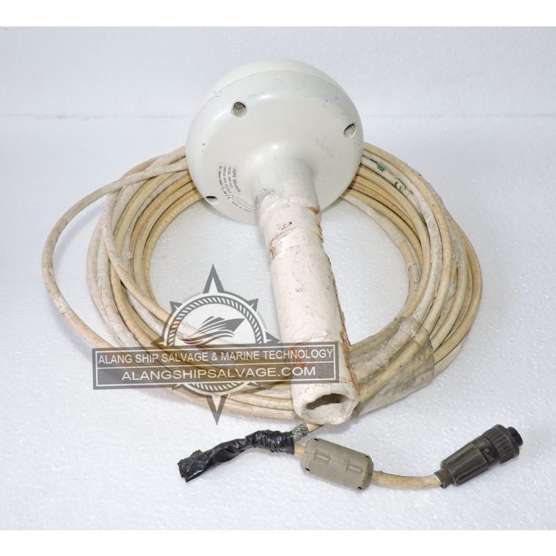
PRODUCT NAME : DGPS SENSOR NNN-4331 COMPANY NAME : JAPAN RADIO CO. LTD. MODEL NUMBER : NNN-4331 PRODUCT DESCRIPTION : The DGPS Sensor NNN-4331 is typically used for high-precision positioning and navigation applications. The Differential Global Positioning System (DGPS) sensor provides enhanced location accuracy compared to standard GPS by correcting signals based on ground reference stations. DGPS can improve positioning accuracy to within a few centimeters, making it suitable for applications that require precise location data. Utilizes correction signals from reference stations to provide real-time adjustments to GPS data. Designed to work with various GPS systems and can often integrate seamlessly with existing navigation and positioning equipment. Widely used in maritime applications for safe navigation and anchoring. Enhances navigation accuracy for aircraft, particularly in approaches and landings. Essential for land surveying, construction, and mapping projects requiring high precision. Used in the navigation systems of autonomous vehicles and drones.
$600.00
PRODUCT NAME : FURUNO GP1850 DGPS MODULE GR-7000-A COMPANY NAME : FURUNO MODEL NUMBER : GR-7000-A PRODUCT DESCRIPTION : The Furuno GP1850 DGPS Module GR-7000-A is a specialized navigation device designed for precise positioning in marine and other applications. The GP1850 module provides high-accuracy positioning using Differential GPS (DGPS) technology, enhancing standard GPS performance. Offers improved accuracy, typically within a few centimeters, making it ideal for navigation and positioning tasks. Designed with an intuitive interface for easy operation and configuration. Can be integrated with other Furuno products and various marine systems, such as chart plotters and radar units. Widely used in commercial and recreational vessels for safe navigation, route planning, and anchoring. Useful in the fishing industry for locating optimal fishing grounds and tracking movement. Employed in hydrographic and geodetic surveying where high precision is essential.
$600.00
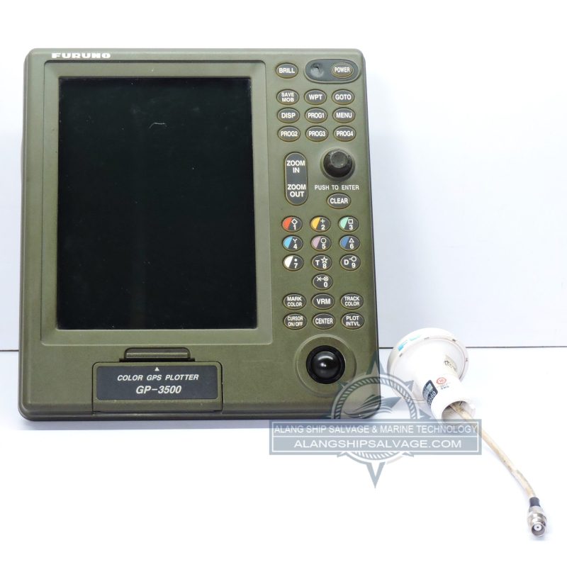
PRODUCT NAME : FURUNO GP3500 COLOR GPS PLOTTER COMPANY NAME : FURUNO MODEL NUMBER : GP3500 PRODUCT DESCRIPTION : The Furuno GP3500 Color GPS Plotter is a highly regarded navigation device used primarily in marine applications. The GP3500 is designed to provide accurate positioning and navigation information for vessels, enhancing safety and efficiency on the water. Features a bright, high-resolution color display for clear visibility under various lighting conditions, making it easier to read charts and navigation data. Intuitive controls and menu navigation simplify operation, allowing users to quickly access essential functions. Utilizes advanced GPS technology to provide precise location data, crucial for navigation and route planning. Supports various chart formats, allowing users to upload and utilize electronic charts for detailed navigation. Enables users to create and manage waypoints and routes for efficient navigation. Widely used by commercial and recreational boaters for safe navigation, including offshore and inland waterway travel.
$1,560.00
PRODUCT NAME : FURUNO GPS ANTENNA MODEL NO GPA 017 NEW COMPANY NAME : FURUNO MODEL NUMBER : GPA 017 NEW PRODUCT DESCRIPTION : The Furuno GPS Antenna Model GPA 017 is designed to provide reliable GPS positioning and is commonly used in marine and land-based applications. The GPA 017 serves as a satellite receiver that captures GPS signals, allowing connected devices to determine precise location data. Designed for excellent signal reception, ensuring reliable performance even in challenging environments. Generally comes with mounting hardware and straightforward installation instructions, allowing for quick setup. Widely used in boats and ships for navigation, enabling accurate positioning and route planning. Utilized in various surveying applications where precise location data is essential. Can be integrated into various land-based navigation systems for accurate tracking and positioning. Usually includes manuals and installation guides to assist users with setup and operation.
$460.00
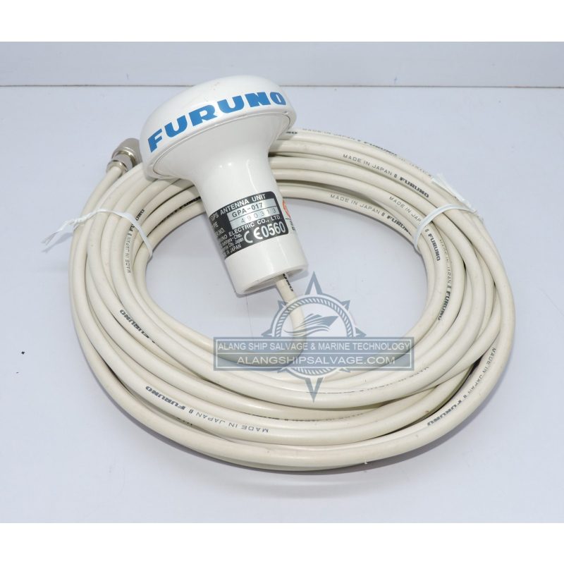
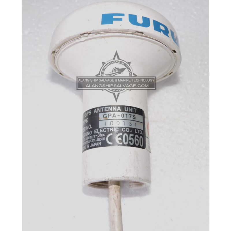
PRODUCT NAME : FURUNO GPS ANTENNA UNIT GPA-017S COMPANY NAME : FURUNO MODEL NUMBER : GPA 017S PRODUCT DESCRIPTION : The Furuno GPS Antenna Unit GPA-017S is designed for precise positioning and navigation, particularly in marine environments. The GPA-017S is a GPS antenna that receives signals from GPS satellites, providing accurate location data for navigation systems. Engineered to ensure strong signal reception, even in challenging environments, which enhances overall GPS accuracy. Its durable construction makes it suitable for marine applications, able to withstand harsh weather conditions. Typically comes with mounting accessories and clear instructions for straightforward installation on vessels or other platforms. Commonly used in boats, ships, and other marine vessels for navigation and positioning. Commonly used in boats, ships, and other marine vessels for navigation and positioning. Can also be used in land vehicles for accurate tracking and navigation.
$460.00
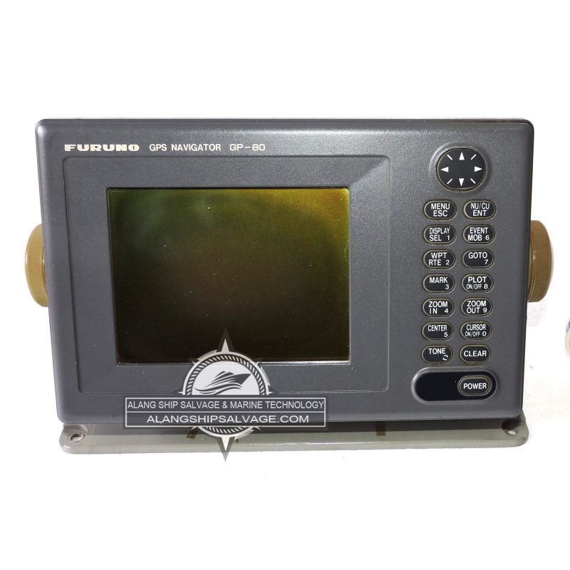
PRODUCT NAME : FURUNO GPS NAVIGATOR GP-80 COMPANY NAME : FURUNO MODEL NUMBER : GP-80 PRODUCT DESCRIPTION : The Furuno GPS Navigator GP-80 is a reliable and user-friendly navigation device designed for marine applications. The GP-80 is designed to provide accurate GPS positioning and navigation information for vessels, enhancing safety and efficiency at sea. Equipped with a clear, easy-to-read display that provides essential navigation data, including charts and waypoint information. Intuitive controls and menu navigation make it accessible for both novice and experienced users. Offers reliable and accurate positioning by using signals from multiple satellites. Allows users to create, edit, and navigate to waypoints and routes for efficient navigation planning. Supports electronic charts, enabling users to view and manage detailed navigation information.
$660.00
PRODUCT NAME : FURUNO GPS NAVIGATOR GP-80 WITH GPS ANTENNA UNIT GPA-017S COMPANY NAME : FURUNO MODEL NUMBER : GP-80 GPA-017S PRODUCT DESCRIPTION : The Furuno GPS Navigator GP-80 paired with the GPA-017S GPS Antenna Unit is an effective navigation system designed for marine applications. This combination provides accurate positioning and navigation information, ensuring safe and efficient travel on water. The GP-80 features a clear display that shows navigation data, waypoints, routes, and other essential information. Intuitive controls allow easy operation, making it accessible for both new and experienced users. Delivers precise location data by receiving signals from multiple satellites. Users can easily create, edit, and navigate to waypoints and routes, enhancing trip planning. Supports various electronic chart formats for detailed navigation. Ensures strong signal reception for accurate positioning, even in challenging conditions.
$1,000.00
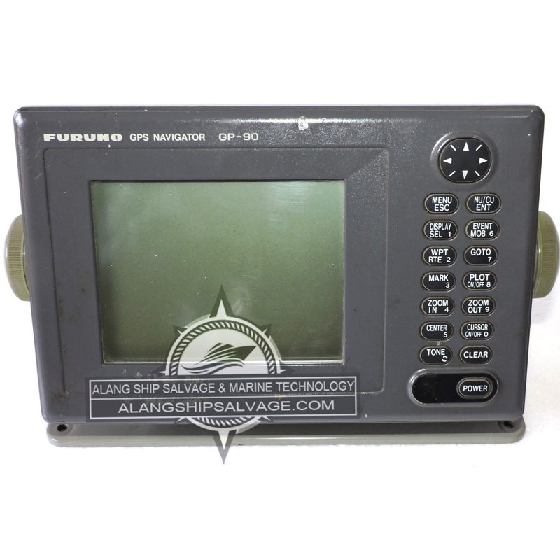
PRODUCT NAME : FURUNO GPS NAVIGATOR GP-90 COMPANY NAME : FURUNO MODEL NUMBER : GP-90 PRODUCT DESCRIPTION : The Furuno GPS Navigator GP-90 is a sophisticated navigation device designed for marine environments, providing accurate positioning and enhanced navigation capabilities. The GP-90 is engineered to assist mariners in navigating safely and efficiently, utilizing advanced GPS technology. Features a bright, easy-to-read display that presents navigation information clearly, even in direct sunlight. The interface is designed for intuitive operation, allowing users to easily access functions and navigate menus. Provides precise location data by acquiring signals from multiple GPS satellites, ensuring high accuracy. Allows users to create, edit, and store waypoints and routes, making trip planning straightforward and efficient. Supports various electronic charts, enabling detailed navigation and improved situational awareness.
$1,000.00
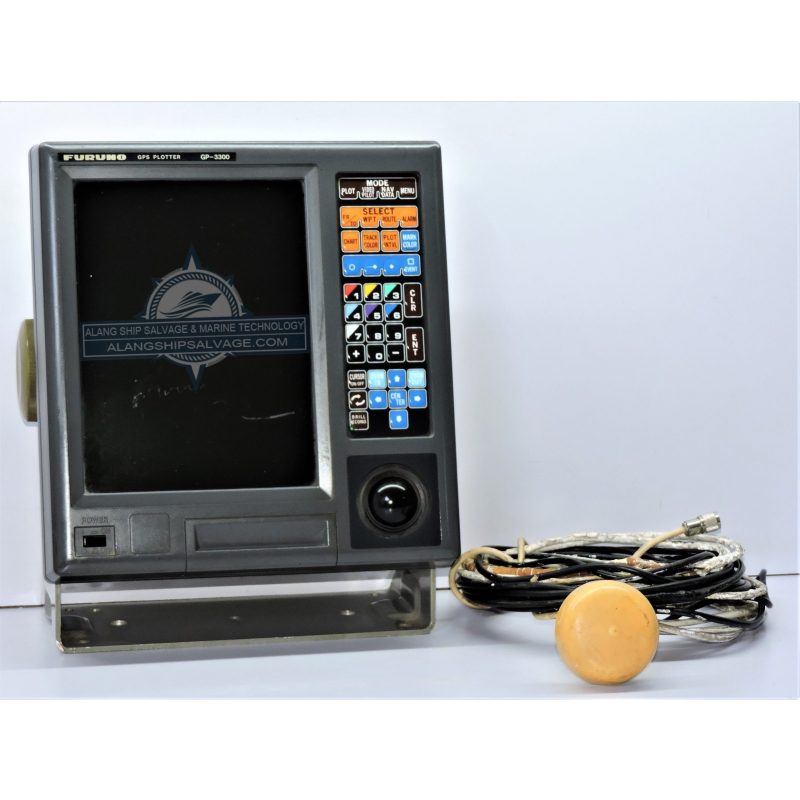
PRODUCT NAME : FURUNO GPS PLOTTER GP 3300 COMPANY NAME : FURUNO MODEL NUMBER : GP 3300 PRODUCT DESCRIPTION : The Furuno GPS Plotter GP-3300 is a versatile and user-friendly navigation device designed for marine applications. The GP-3300 is designed to provide accurate GPS positioning and enhance navigation capabilities for vessels. Equipped with a bright, clear display that provides essential navigation information, making it easy to read in various lighting conditions. Intuitive controls and menus facilitate easy operation for users of all experience levels. Offers precise positioning by receiving signals from multiple GPS satellites, ensuring reliability. Users can create, edit, and manage waypoints and routes, enhancing trip planning and navigation efficiency. Supports various electronic chart formats, allowing users to utilize detailed navigation charts for improved situational awareness.
$1,560.00
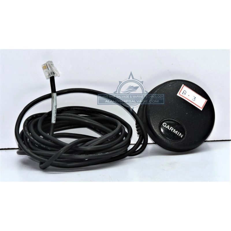
PRODUCT NAME : GARMIN GPS ANTENNA GPS18X LVC, 5M COMPANY NAME : GARMIN MODEL NUMBER : GPS18X LVC, 5M PRODUCT DESCRIPTION : The Garmin GPS Antenna GPS18X LVC is a high-performance GPS receiver designed for various applications, including marine, automotive, and handheld use. The GPS18X LVC provides accurate GPS positioning and is suitable for integration with various devices, such as chartplotters, computers, and other navigation systems. Offers reliable signal reception, enhancing performance in challenging environments, such as urban canyons or dense foliage. Designed for low power consumption, making it ideal for battery-operated devices and applications where energy efficiency is crucial. Comes with a 5-meter cable for flexible installation options, allowing the antenna to be positioned optimally for signal reception. Its small footprint makes it easy to install in various locations without taking up much space. Commonly used in boats and vessels for navigation and positioning.
$330.00
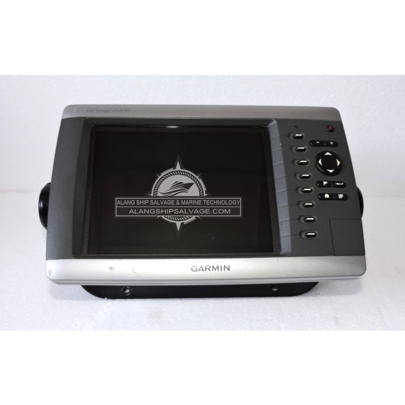
PRODUCT NAME : GARMIN GPSMAP 2008 COMPANY NAME : GARMIN MODEL NUMBER : GPSMAP 2008 PRODUCT DESCRIPTION : The Garmin GPSMAP 2008 is a multifunctional marine GPS device designed for navigation, chart plotting, and marine applications. The GPSMAP 2008 provides accurate navigation and chart plotting capabilities for boaters, enhancing safety and efficiency on the water. Features a bright, color display that offers clear visibility of maps and navigation data, even in bright sunlight. Intuitive controls and menus make it easy for users to access essential functions quickly. Provides reliable positioning by acquiring signals from multiple satellites for improved accuracy. Supports various marine charts, including Garmin's BlueChart and other compatible formats, allowing users to utilize detailed navigation charts. Users can create, edit, and navigate to waypoints and routes, making trip planning straightforward.
$1,560.00
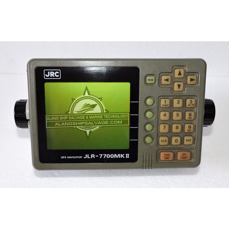
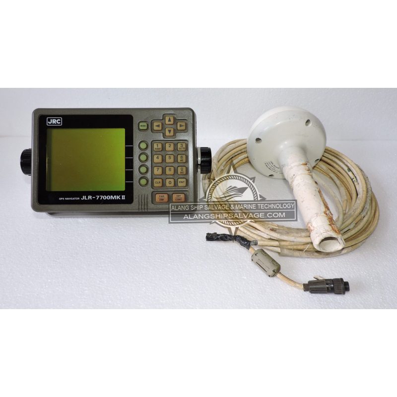
PRODUCT NAME : GPS NAVIGATOR JLR-7700 MK2 COMPANY NAME : JRC MODEL NUMBER : JLR-7700 MK2 PRODUCT DESCRIPTION : The JLR-7700 MK2 GPS Navigator is a sophisticated navigation device designed for maritime applications. The JLR-7700 MK2 is designed to provide accurate navigation and positioning data, enhancing safety and efficiency for marine vessels. Features a clear, easy-to-read screen that presents navigation data and maps, making it user-friendly in various lighting conditions. Offers high sensitivity and accuracy by utilizing signals from multiple GPS satellites, ensuring reliable positioning. Users can create, edit, and store waypoints and routes, which is essential for effective trip planning. Supports various electronic chart formats, allowing users to view detailed navigation information. Designed for easy operation, with intuitive controls and menus that simplify navigation.
$1,000.00
PRODUCT NAME : GRAMIN GSMAP 2008 COMPANY NAME : GRAMIN MODEL NUMBER : GSMAP 2008 PRODUCT DESCRIPTION : Garmin GPSMAP 2008, a multifunctional marine navigation device. Bright, color display that is easy to read in various lighting conditions. High-resolution screen for clear visualization of maps and navigation data. Integrated GPS receiver that provides accurate positioning by receiving signals from multiple satellites. Supports Garmin’s BlueChart and other compatible marine charts for detailed navigation. Users can upload and manage charts for improved situational awareness. Allows users to create, edit, and navigate to waypoints and routes, facilitating effective trip planning. Can interface with other marine electronics, such as radar and autopilot systems, using NMEA 2000 or NMEA 0183 protocols. Ideal for both commercial and recreational vessels. Useful for marking fishing spots and tracking movements. Enhances navigation safety for recreational boaters.
$1,330.00
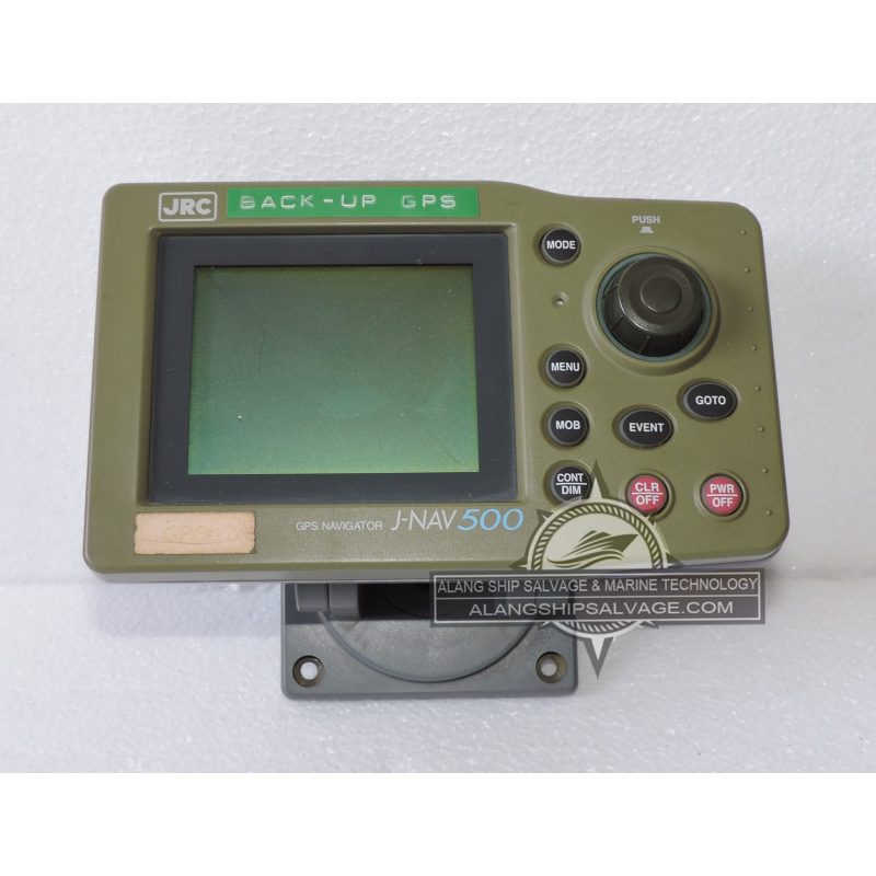
PRODUCT NAME : JRC BACK-UP GPS NAVIGATOR J-NAV500 COMPANY NAME : JRC MODEL NUMBER : J-NAV500 PRODUCT DESCRIPTION : The JRC J-NAV500 is a back-up GPS navigator designed for marine applications, providing reliable positioning and navigation capabilities. The J-NAV500 serves as a backup navigation system to enhance safety and reliability for vessels, particularly in case of primary system failure. Designed for easy operation, with an intuitive display and straightforward controls. Offers accurate positioning by receiving signals from multiple GPS satellites, ensuring reliable performance even in challenging conditions. Space-efficient and suitable for installation in various marine environments without taking up much space. Capable of providing navigation data to other onboard systems, such as chart plotters or autopilots, enhancing overall system integration. Allows users to create, edit, and navigate to waypoints and routes, facilitating effective navigation planning.
$530.00
PRODUCT NAME : JRC DGPS FULL SET JLR - 4341 COMPANY NAME : JRC MODEL NUMBER : JLR - 4341 PRODUCT DESCRIPTION : The JRC JLR-4341 is a Differential GPS (DGPS) system designed for marine applications, providing enhanced positioning accuracy. The JLR-4341 DGPS system is designed to deliver precise navigation data, improving safety and efficiency for maritime operations. Offers improved positioning accuracy compared to standard GPS by utilizing differential corrections from ground stations. Intuitive controls and displays for easy operation and monitoring of navigation data. Can interface with other onboard systems, such as chart plotters and autopilots, using standard protocols like NMEA. Ideal for commercial vessels, fishing boats, and recreational craft, ensuring safe navigation in various water conditions. Useful in hydrographic surveying and other applications requiring high positional accuracy.
$1,560.00
PRODUCT NAME : JRC GPS NAVIGATOR JLR- 77002 MK II COMPANY NAME : JRC MODEL NUMBER : JLR- 77002 MK II PRODUCT DESCRIPTION : The JRC JLR-77002 MK II is a GPS navigator designed for marine applications, offering advanced navigation features and reliability. The JLR-77002 MK II provides accurate positioning and navigation data, enhancing safety and efficiency for vessels operating in various marine environments. Equipped with a clear and bright screen that presents navigation data, waypoints, and routes effectively. Utilizes signals from multiple satellites to deliver high-accuracy positioning. Users can create, edit, and store waypoints and routes, simplifying navigation planning. Compatible with various electronic chart formats, allowing for detailed navigation and improved situational awareness. Designed with intuitive controls and a straightforward menu system for easy operation. Ideal for commercial and recreational vessels, ensuring safe navigation across different waterways.
$1,000.00
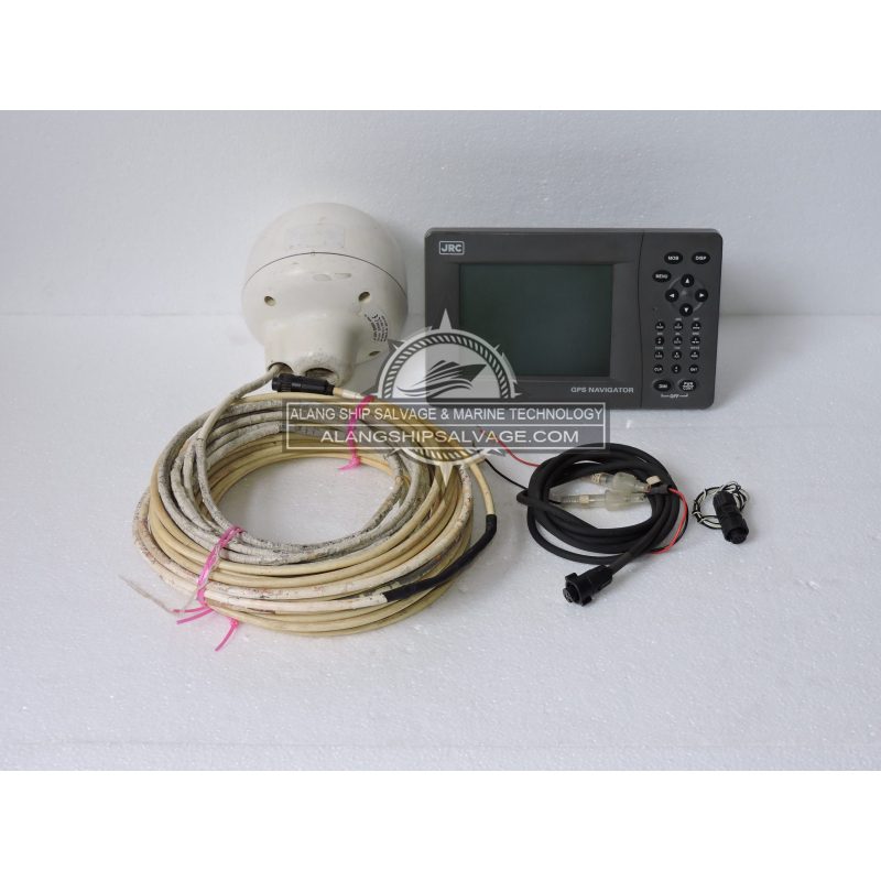
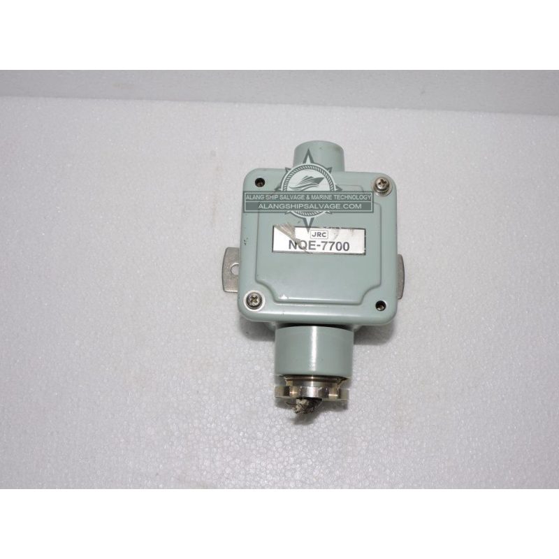
PRODUCT NAME : JRC JUNCTION BOX DGPS SENSOR MARINE NQE-7700A COMPANY NAME : JRC MODEL NUMBER : NQE-7700A PRODUCT DESCRIPTION : The JRC NQE-7700A Junction Box DGPS Sensor is a critical component for achieving high-precision navigation in marine settings. By utilizing Differential GPS (DGPS) technology, the NQE-7700A offers significantly improved accuracy compared to standard GPS, making it ideal for situations where precise positioning is required, such as in busy ports, narrow channels, or shallow waters. Its junction box functionality enables seamless integration with other onboard marine electronics, streamlining installation and enhancing system reliability. Built with a durable, weather-resistant design, the NQE-7700A can withstand the harsh conditions of the maritime environment, ensuring longevity and consistent performance. Whether you are operating a commercial vessel, a fishing boat, or any other vessel requiring highly accurate navigation, the JRC NQE-7700A provides the precise location data and connectivity needed for safe, efficient, and reliable maritime operations.
$130.00
PRODUCT NAME : KODEN GPS ANTENNA GA-08 COMPANY NAME : KODEN MODEL NUMBER : GA-08 PRODUCT DESCRIPTION : The Koden GA-08 GPS Antenna is designed for reliable GPS signal reception in marine and other applications. The GA-08 serves as a high-performance GPS antenna, enhancing positioning accuracy for various navigation systems. Provides strong signal reception, ensuring reliable performance in various environmental conditions. Built to withstand harsh marine environments, including exposure to saltwater and UV rays, ensuring longevity and reliability. Its low-profile design allows for easy installation on vessels without occupying excessive space. Typically includes mounting hardware and straightforward installation instructions for quick setup. Commonly used in boats and ships for accurate navigation and positioning. Can be integrated into automotive navigation systems for precise tracking. Suitable for applications requiring accurate GPS data.
$330.00
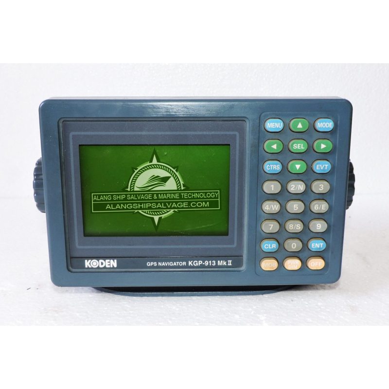
PRODUCT NAME : KODEN GPS NAVIGATOR KGP-913 MK II COMPANY NAME : KODEN MODEL NUMBER : KGP-913 MK II PRODUCT DESCRIPTION : The Koden KGP-913 MK II is a marine GPS navigator designed to provide accurate positioning and navigation for a variety of vessels. The KGP-913 MK II enhances maritime navigation by providing reliable GPS data, ensuring safer and more efficient travel on water. Features a clear and bright screen for easy visibility of maps and navigation information, even in direct sunlight. Offers high sensitivity and accuracy by receiving signals from multiple GPS satellites. Designed with intuitive menus and controls that simplify navigation and operation. Users can create, store, and navigate to waypoints and routes, aiding in trip planning and navigation. Supports various electronic chart formats, allowing users to integrate detailed charts into their navigation system. Ideal for recreational and commercial vessels, ensuring safe navigation across different waterways.
$860.00
PRODUCT NAME : KODEN GPS NAVIGATOR KGP-913 MK2 COMPANY NAME : KODEN MODEL NUMBER : KGP-913 MK 2 PRODUCT DESCRIPTION : The Koden KGP-913 MK2 is a reliable marine GPS navigator designed to enhance navigation and safety for various vessels. The KGP-913 MK2 provides precise GPS positioning and navigation information, making it an essential tool for safe marine travel. Features a bright, clear display that allows for easy reading of maps and navigation data, even in bright sunlight. Utilizes advanced satellite technology to ensure accurate positioning and reliable signal reception. Designed with intuitive controls and straightforward navigation menus, making it accessible for users of all experience levels. Allows users to create, edit, and navigate to waypoints and routes, facilitating effective trip planning. Supports various electronic chart formats, allowing integration with detailed navigational charts for enhanced situational awareness.
$530.00
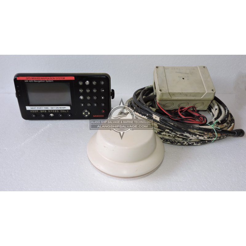
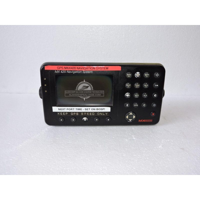
PRODUCT NAME : LEICA GPS NAVIGATION SYSTEMS MX-420 DISPLAY WITH ANTENNA COMPANY NAME : MX MARINE MODEL NUMBER : MX-420 PRODUCT DESCRIPTION : The LEICA MX-420 is a GPS navigation system designed for various surveying and mapping applications. The MX-420 features a clear, high-resolution screen that provides easy visibility of maps and data, even in bright sunlight. It utilizes advanced GPS technology for accurate positioning, making it suitable for both outdoor and indoor applications. The system includes a built-in antenna that enhances signal reception, ensuring reliable navigation even in challenging environments. The intuitive interface allows for easy operation, enabling users to quickly access navigation tools and data. Designed for rugged environments, the MX-420 is built to withstand harsh conditions, making it ideal for fieldwork. Suitable for various industries, including construction, forestry, and agriculture, facilitating precise surveying and mapping tasks.
$1,875.00
PRODUCT NAME : LEICA GPS NAVIGATION SYSTEMS MX-420-2 DISPLAY COMPANY NAME : LEICA MODEL NUMBER : MX-420-2 PRODUCT DESCRIPTION : The LEICA MX-420-2 GPS navigation system is an advanced solution designed for precision in surveying and mapping. The MX-420-2 features dual high-resolution displays, enhancing visibility and allowing users to view multiple data sets simultaneously. Equipped with advanced GNSS capabilities, it supports multiple satellite systems (GPS, GLONASS, Galileo) for improved accuracy and reliability. The system includes a high-performance integrated antenna that optimizes signal reception, even in challenging environments. The intuitive touchscreen interface simplifies navigation and data management, making it accessible for users of all skill levels. Built to withstand harsh field conditions, the MX-420-2 is rugged and weatherproof, ensuring reliable performance in various environments. Offers real-time data processing for immediate analysis and decision-making, enhancing workflow efficiency.
$1,330.00
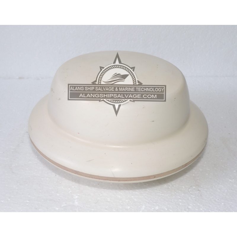
PRODUCT NAME : LEICA SMART ANTENNA MX-420 COMPANY NAME : LEICA MODEL NUMBER : MX-420 PRODUCT DESCRIPTION : The LEICA Smart Antenna MX-420 is a cutting-edge GNSS solution designed for various surveying and geospatial applications. Supports multiple satellite systems, including GPS, GLONASS, Galileo, and BeiDou, ensuring high accuracy and reliability. Lightweight and easy to transport, making it suitable for fieldwork without compromising performance. Built-in processing capabilities allow for real-time data processing, enhancing efficiency during surveys. Simplified interface for easy setup and operation, suitable for users with varying levels of experience. Designed to withstand harsh environmental conditions, ensuring reliable operation in the field. Offers Bluetooth and Wi-Fi options for seamless integration with other devices and easy data transfer. Can be powered via rechargeable batteries or external power sources, providing flexibility for extended field use. Ideal for precise positioning and data collection. Useful for site management and layout tasks. Supports precision farming and land management.
$1,000.00
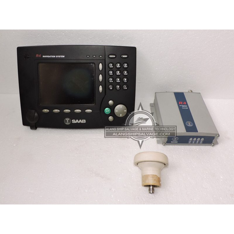
PRODUCT NAME : SAAB R4 NAVIGATION SYSTEM FULL SET COMPANY NAME : SAAB MODEL NUMBER : R4 DGPS SENSOR PRODUCT DESCRIPTION : The SAAB R4 Navigation System is a comprehensive solution designed for aviation applications, known for its reliability and advanced features. Combines various navigation technologies, including GPS, inertial navigation, and VOR/ILS systems for accurate positioning. Features an intuitive display and control layout, allowing pilots to access information quickly and easily during flight. High-resolution screens provide clear visibility of maps, flight paths, and navigation data, even in challenging lighting conditions. Capable of processing navigation data in real-time for immediate feedback and adjustments during flight. Designed to withstand harsh operating conditions, ensuring dependable performance in various environments. The system can be customized with additional modules for enhanced functionality, such as weather radar and terrain awareness.
$1,560.00
PRODUCT NAME : SAAB R5 GPS FULL SET COMPANY NAME : SAAB MODEL NUMBER : R5 GPS PRODUCT DESCRIPTION : The SAAB R5 GPS is a sophisticated navigation system designed primarily for aviation applications, known for its precision and advanced capabilities. Utilizes advanced GPS technology for accurate positioning and navigation, essential for modern aviation operations. Intuitive controls and displays make it easy for pilots to access critical navigation information quickly. Processes navigation data in real time, providing immediate feedback and adjustments for enhanced situational awareness. Seamlessly integrates with other avionics systems, such as autopilots, flight management systems, and communication systems. Built to withstand harsh environmental conditions, ensuring reliable operation in diverse flight scenarios. Can be customized with additional features and modules, such as weather data, terrain awareness, and traffic information systems.
$2,810.00
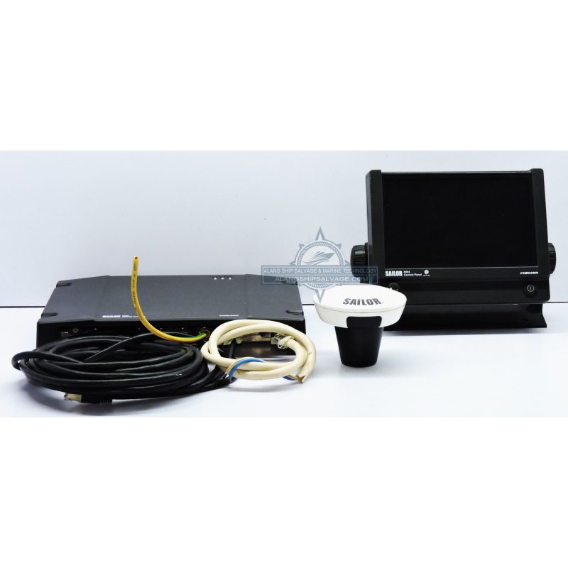
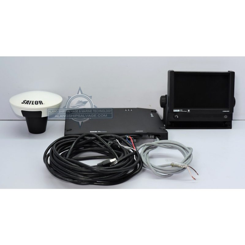
PRODUCT NAME : SAILOR 6570 DGNSS SYSTEM COMPANY NAME : SAILOR MODEL NUMBER : 6570 PRODUCT DESCRIPTION : The SAILOR 6570 DGNSS (Differential Global Navigation Satellite System) is a robust maritime navigation solution designed for precise positioning in challenging marine environments. Offers accurate positioning by using differential corrections from GNSS, improving reliability for marine applications. Features an intuitive display and controls, making it easy for operators to access navigation data and settings. Supports multiple GNSS signals (GPS, GLONASS, Galileo) for enhanced accuracy and reliability in various conditions. Engineered for harsh marine environments, ensuring durability and reliable performance even in extreme conditions. Provides real-time differential corrections for immediate improvements in positioning accuracy. Suitable for a range of maritime applications, including navigation, surveying, and positioning for offshore activities. Easily integrates with existing onboard systems, such as ECDIS (Electronic Chart Display and Information System) and other navigation tools.
$2,180.00
PRODUCT NAME : SAILOR 6588 DGNSS RECEIVER COMPANY NAME : SAILOR MODEL NUMBER : 6588 PRODUCT DESCRIPTION : The SAILOR 6588 DGNSS Receiver is a highly specialized maritime navigation device designed to provide precise positioning using Differential Global Navigation Satellite System technology. Delivers enhanced positioning accuracy by utilizing differential corrections from GNSS signals, which is crucial for marine operations. Compatible with multiple satellite systems, including GPS, GLONASS, and Galileo, ensuring reliable performance in various environments. Equipped with an intuitive interface that allows operators to easily monitor and manage navigation data. Built to withstand harsh marine conditions, ensuring durability and consistent performance in demanding environments. Easily integrates with other onboard systems, such as ECDIS and autopilots, to create a comprehensive navigation suite. Designed for easy installation, the compact form factor makes it suitable for a variety of vessels.
$2,180.00
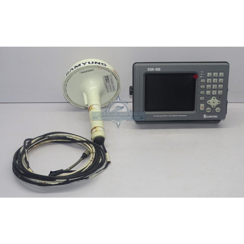
PRODUCT NAME : SAMYUNG GLONASS GPS MODEL SGN-500 COMPANY NAME : SAMYUNG MODEL NUMBER : SGN-500 PRODUCT DESCRIPTION : The SAMYUNG SGN-500 is a specialized GPS and GLONASS navigation system designed for marine and industrial applications. Supports both GPS and GLONASS, providing enhanced accuracy and reliability in various operating conditions. Offers precise positioning data, crucial for navigation, surveying, and other applications that require accurate location information. Features an intuitive interface that simplifies operation and data access for users, making it suitable for various skill levels. Built to withstand harsh environmental conditions, ensuring reliable performance in marine and industrial settings. Provides real-time positioning data, which is essential for dynamic applications such as navigation and monitoring. Designed for easy installation and space efficiency, making it suitable for a wide range of vessels and applications.
$1,130.00
PRODUCT NAME : SAMYUNG GPS RECEIVER SPR-1400 COMPANY NAME : SAMYUNG MODEL NUMBER : SPR-1400 PRODUCT DESCRIPTION : The SAMYUNG SPR-1400 is a high-performance GPS receiver designed for marine and industrial applications. Offers excellent sensitivity for accurate positioning even in challenging environments, such as urban canyons or dense foliage. Compatible with multiple satellite systems, including GPS and GLONASS, enhancing accuracy and reliability. Features an intuitive interface for easy operation and monitoring of navigation data. Provides real-time data output, essential for dynamic navigation and tracking applications. Designed to withstand harsh marine conditions, ensuring durability and reliable performance in various environments. Supports various NMEA output formats, allowing integration with different marine electronics and navigation systems. Easy to install and integrate into various vessels and applications due to its compact design. Ideal for commercial vessels, fishing boats, and recreational craft requiring precise positioning.
$1,000.00
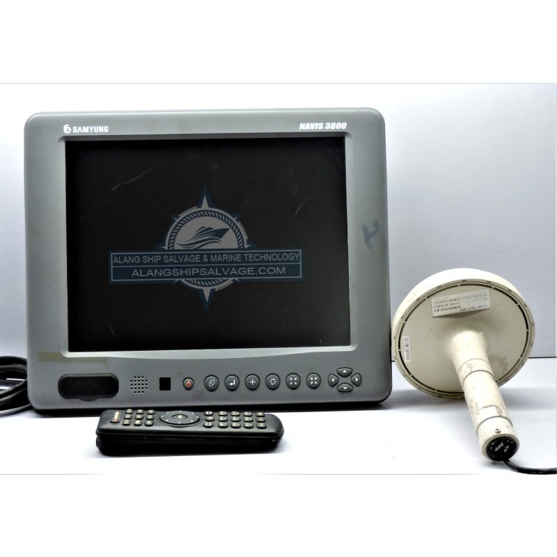
PRODUCT NAME : SAMYUNG NAVIS 3800 GPS PLOTTER COMPANY NAME : SAMYUNG MODEL NUMBER : 3800 GPS PRODUCT DESCRIPTION : The SAMYUNG NAVIS 3800 GPS Plotter is a comprehensive marine navigation device designed for professional and recreational use. Equipped with a bright, high-resolution screen that ensures clear visibility of charts, maps, and navigation data, even in bright sunlight. Combines GPS functionality with advanced chart plotting capabilities, providing accurate positioning and navigation. Features an intuitive interface that simplifies navigation and operation, making it accessible for users of all experience levels. Compatible with a variety of electronic chart formats, allowing users to access up-to-date navigational information. Processes and displays real-time data, such as speed, heading, and waypoint navigation, essential for effective route planning and tracking. Built to withstand harsh marine environments, ensuring reliability and longevity in challenging conditions. Supports various NMEA inputs and outputs, allowing for seamless integration with other marine electronics, such as radar, autopilots, and AIS. Users can easily create, edit, and manage waypoints and routes, enhancing navigation efficiency.
$1,375.00
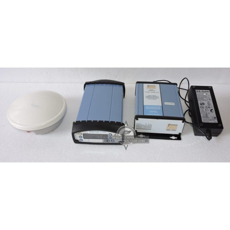
PRODUCT NAME : SEASTAR DGPS FULL SET 9205-GNSS FUGRO COMPANY NAME : SEASTAR / FUGRO MODEL NUMBER : 9205-GNSS PRODUCT DESCRIPTION : The SEASTAR DGPS Full Set 9205-GNSS by Fugro is a powerful, high-precision marine positioning system that uses Differential GPS (DGPS) and GNSS technology to deliver highly accurate and reliable navigation data. It is designed to enhance the accuracy of GPS-based positioning, which is critical for demanding marine applications like surveying, offshore construction, and vessel navigation. With its ability to integrate real-time correction data and multiple satellite constellations, the SEASTAR 9205-GNSS ensures optimal precision in a wide range of environments. Its rugged design makes it ideal for harsh maritime conditions, and it offers flexible integration with other marine systems, supporting communication protocols such as NMEA 0183 and NMEA 2000. Whether used for hydrographic surveying, offshore construction, or high-precision navigation, the SEASTAR DGPS Full Set 9205-GNSS ensures reliable and accurate positioning, providing the foundation for safe and efficient marine operations.
$3,430.00
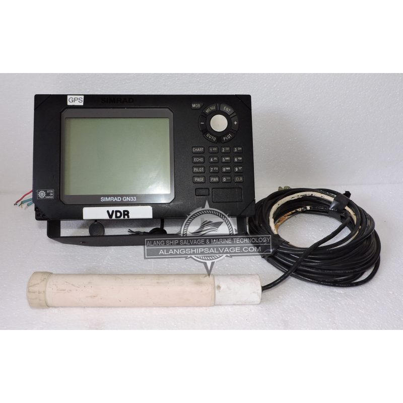
PRODUCT NAME : SIMRAD GN33 GPS NAVIGATOR COMPANY NAME : SIMRAD MODEL NUMBER : GN33 GPS PRODUCT DESCRIPTION : The SIMRAD GN33 GPS Navigator is a sophisticated marine navigation device designed for accurate positioning and ease of use in various maritime applications. Utilizes advanced GNSS technology, providing precise positioning through multiple satellite systems, including GPS and GLONASS. Features an intuitive touchscreen interface that simplifies navigation and access to various functions and settings. Provides real-time updates on position, speed, heading, and other critical navigational data, enhancing situational awareness. Compatible with a wide range of electronic charts, allowing users to navigate with up-to-date maritime information. Easily create, edit, and manage waypoints and routes for effective navigation planning. Built to withstand harsh marine environments, ensuring reliability in demanding conditions. Can be integrated with other Simrad and third-party marine electronics, such as radar, fish finders, and autopilots, to create a cohesive navigation system. Supports NMEA 0183 and NMEA 2000 protocols for seamless communication with other onboard systems.
$1,000.00
PRODUCT NAME : TRIMBLE DGPS MODEL NO SPS351 COMPANY NAME : TRIMBLE MODEL NUMBER : SPS351 PRODUCT DESCRIPTION : The Trimble SPS351 is a high-performance DGPS (Differential Global Positioning System) receiver designed for precise positioning in various applications, including surveying, construction, and agriculture. Provides accurate positioning using DGPS corrections, significantly improving location accuracy over standard GPS. Compatible with multiple satellite systems, including GPS and GLONASS, which enhances reliability and performance in challenging environments. Offers real-time differential corrections to deliver immediate updates on position accuracy. Features an intuitive interface for easy configuration and monitoring of GPS data. Built to withstand harsh environmental conditions, ensuring durability and reliable performance in the field. Supports various communication protocols for integration with other systems and devices, enhancing versatility in different applications. Lightweight and easy to transport, making it suitable for a variety of field applications.
$1,875.00
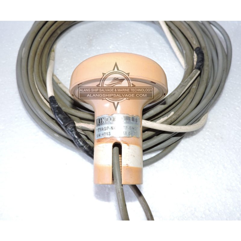
PRODUCT NAME : XIOO ANTENNA UNIT ZYGP-N412-TF-BNCM COMPANY NAME : XIOO MODEL NUMBER : ZYGP-N412-TF-BNCM PRODUCT DESCRIPTION : The XIOO Antenna Unit ZYGP-N412-TF-BNCM is designed for high-performance GNSS applications. Compatible with various GNSS signals, including GPS, GLONASS, Galileo, and BeiDou, ensuring versatility and reliability in positioning. Offers excellent signal reception, which enhances performance in challenging environments with poor satellite visibility. Lightweight and compact, making it suitable for various applications without taking up much space. Built to withstand harsh environmental conditions, ensuring longevity and reliability in outdoor settings. Designed for straightforward installation, allowing for quick setup in a range of applications. Operates across a wide frequency range, which supports different GNSS bands for improved accuracy.
$330.00